The risk of water erosion on the foothills of the Middle High Atlas (Morocco): Tagueleft basin case study
Rizki Mohamed
Faculty of Letters and Human Sciences || Mohammed V University || Rabat || Morocco
Tab title
The Tagueleft basin is geographically located in the northern edges of the Middle High Atlas, which is a geomorphological fragile area. The impact of human activity has accelerated water erosion in this mountains area. This is reflected in dynamic and instable foothills, a decrease in forests density and a degradation in the production of the land. On the other hand, land degradation due to human over-exploitation of natural resources has increased land degradation in the area. The interest in the risk of erosion on the foothills in the area under study comes in the context of our contribution to clarify the role of geomatical and geomorphological approaches in explaining and identifying the mechanisms responsible for current foothills dynamism through water erosion and its negative impacts on the environment and local development. The aim of the study was to use the EPM (Erosion Potential Méthod) which is formulated by Slobodan Gavrilovic for erosion in mountainous areas and to test the reliability of its results based on fieldwork and remote sensing data. The results of the erosion assessment and its quantification by applying the coefficient (W) for theoretical model in area under study have showen that erosion is very important and it touches on wide areas as it appears through the domain classification of the distribution erosion in Tagueleft basin. Keywords: the central High Atlas- Water erosion- Slope dynamics- Degradation of fragile areas- Remote Sensing.
خطر التعرية المائية على السفوح بالأطلس الكبير الأوسط (المغرب):
دراسة حالة حوض تاكلفت
محمد رزقي
كلية الآداب والعلوم الإنسانية || جامعة محمد الخامس || الرباط || المغرب
Tab title
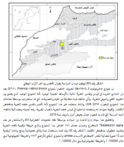
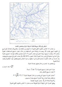
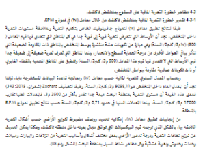
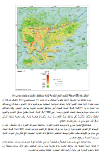
يقع منخفض تاكلفت بالحاشية الشمالية للأطلس الكبير الأوسط. وقد ساهمت علاقة الإنسان بوسطه البيئي في تسريع وتيرة التعرية المائية بالمنطقة، ويتجسد ذلك من خلال دينامية وعدم استقرار السفوح وتراجع كثافة التشكيلات الغابوية وتدهور الطاقة الإنتاجية للأراضي. إن تضافر الظروف المناسبة للتعرية بالحوض ناتجة عن التفاعل بين الآليات الطبيعية المتمثلة في الوضع الطوبوغرافي وهشاشة الإرث الجيومرفولوجي وتدهور الغطاء النباتي، والآليات البشرية المجسدة في تزايد حدة الضغط البشري على الوسط. إن الاهتمام بخطورة التعرية على مستوى السفوح بهذا الوسط الجبلي الهش طبيعيا والفقير تنمويا، يأتي في سياق مساهمتنا في إبراز دور مقاربتي الجيومعلوماتية والجيومرفلوجيا في تفسير مختلف الآليات المسؤولة عن الدينامية الحالية للسفوح وتشخيص ذلك من خلال التعرية المائية وانعكاساتها السلبية على البيئة والتنمية المحلية. وقد كلن الهدف من الدراسة توظيف نموذج E.P.M Potential Méthod) Erosion) الذي صاغه سلوبودان جافريلوفيك Gavrilovic.S للتعرية بالمناطق الجبلية واختبار مصداقية نتائجه بالاعتماد على العمل الميداني وبيانات الاستشعار عن بعد، وتبين من نتائج تقييم التعرية وتكميمها بتطبيق معامل (W) الخاص بهذا النموذج النظري بمنطقة البحث أن التعرية مهمة جدا وتلامس مجالات واسعة كما يتضح من التصنيف المجالي لتوزيع دينامية التعرية التي تم استخلاصها، مما يستوجب تدخلا معجلا. الكلمات المفتاحية: الأطلس الكبير الأوسط – التعرية المائية-دينامية السفوح – تدهور الأوساط الهشة-الاستشعار عن بعد