Spatio-Temporal Analysis of Rainfall Variability and its Prediction
in AlQassim Region Using (1987-2017)
Aljazy Khalid Alturki
Ahmad Abdullah Aldughairi
College of Arabic Language and Social studies || Qassim University || KSA
Tab title
This study aimed to analyze the indicators of spatial and temporal distribution of daily, monthly, and seasonal rainfall measurements. It is looking for the possibility of the stability or change of precipitation properties by using the data of the present. Also, it is working with the most important factors that effects on the rainfall, Moreover, many of some statistical methods applied in this study. Using inverted distance weighted Inverse Distance Weighting (IDW) method to generates rain interpolation surface that is tool approves in geographic information systems software. Rain is an important element of many economic activities. Therefore, the importance of predicting the spatial distribution of precipitation that is important from water rain resources. This study presents an analysis of spatiotemporal variation of the daily, monthly and seasonal rainfall in Qassim region, based on data seven weather stations, that is including, Buraidah, Unaizah, Al Rasa, and the General Authority for Meteorology and Environmental Protection, also Prince Nayef Airport Station between (2017-1987) which period included 31 years for the accuracy of the results. The study reached to several recommendations that can be used in geographical fields, whether environmental or human, which are related to water resources and torrents, rainwater drainage projects and urban areas to avoid disasters. Keywords: Variance, Possibility of precipitation, weighted Inverse Distance Weighting.
التحليل المكاني والزماني لتباين التهاطل المطري والتنبؤ به في منطقة القصيم (2017-1987)
الجازي خالد التركي
أحمد بن عبد الله الدغيري
كلية اللغة العربية والدراسات الاجتماعية || جامعة القصيم || المملكة العربية السعودية
Tab title
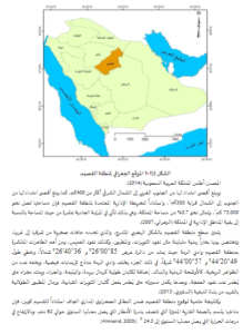
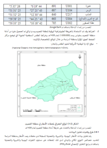
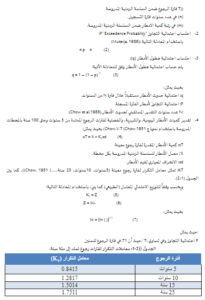
هدفت هذه الدراسة إلى تحليل مؤشرات التوزيع المكاني والزماني لكميات التهاطل اليومية، الشهرية، الفصلية. ومحاولة التنبؤ باحتمالية ثبات أو تغير خصائص التهاطل المطري من بيانات الحاضر. وتعاملت هذه الدراسة مع أبرز العوامل المؤثرة على تساقط الأمطار. وعلاوة على ذلك تعاملت مع بعض الأساليب الإحصائية، والبرامج الحاسوبية، ونماذج نظم المعلومات الجغرافية مثل أسلوب مقلوب المسافة الموزونة Inverse Distance Weighting (IDW) لبناء سطوح التنبؤ المطري، وقدمت هذه الدراسة تحليلاً للتباين المكاني والزماني اليومي، والشهري، والفصلي للأمطار بمنطقة القصيم من خلال الاعتماد على بيانات 7 محطات مطرية منها ما هو تابع لوزارة البيئة والمياه والزراعة متمثلة في محطات بريدة، وعنيزة، والرس، والبدائع، والمذنب، وعقلة الصقور، والمحطة التابعة للهيئة العامة للأرصاد وحماية البيئة المتمثلة بمحطة مطار الأمير نايف للفترة (2017-1987) بسلسلة زمنية امتدت إلى 31 سنة بما يضمن دقة النتائج. وتوصلت الدراسة لعدة توصيات يمكن الاستفادة منها في كافة المجالات سواءً البيئية، أو البشرية، ولعل أبرزها ما يتعلق بالموارد المائية والسيول، والعمل على تطوير مشاريع تصريف مياه الأمطار، والحد من الامتداد العمراني وسط مجاري الأودية؛ لتفادي الكوارث والخسائر الإنسانية، والمادية. الكلمات المفتاحية: التباين، احتمالية التهاطل، أسلوب مقلوب المسافة الموزونة.