Spatial analysis of Archaeological and historical sites and their relationship with the Natural and Human Factors case study: Al Baha region
Ashwag Said Alahmari
Sarra Al-Habib Ouerghi
Faculty of Arts & Humanities || King Abdulaziz University || Jeddah || KSA
Tab title
This paper aims to identify the archaeological and historical sites, the geographical distribution, and the spatial relations between them and other geographical phenomena in Al-Baha, which provides us with a comprehensive view of the current status of these archaeological and historical sites and developing awareness of its importance as tourist sites. To achieve the research goals, to achieve research objectives, the spatial analysis approach in the GIS environment was used to measure spatial geographical phenomena in the study area through its statistical and spatial analysis tools. The cartographic presentation and mapping method was adopted using the GIS software 10.6. The study concluded that the number of archaeological and historical sites in Al-Baha has reached about 129 sites distributed among 7 governorates. Its relative distribution was very different between the western and eastern parts of the region (about 97 archaeological and historical sites in east and 32 archaeological and historical sites west, with 75% of sites in the east and 25% of sites in the west) in close association with topography, water resources, mineral resources and historic trade routes. The distribution of archaeological and historical sites in the area of Al-Baha was a close distribution in its entirety (Neighborhood Index=0.63) due to the limitation and small areas of plains that are suitable for settlement and the proliferation of the steep highlands and vast desert over the area of Al-Baha. The density of archaeological and historical sites was high in the eastern part, and fell in the western part of the study area. The study recommended the importance of using GIS applications to study the spatial distribution of archaeological and historical sites and the spatial relations between them and the various natural and human phenomena in the study area. Using the spatial analysis output to prepare archaeological atlas containing maps, illustrations and photographs of the archaeological and historical sites in the region for the purpose of exploiting and commercializing these potential resources. Also, encouraging studies and research that contribute to highlighting the importance of archaeological and historical sites and encouraging exploiting them in several special fields, including tourism. Keywords: Archaeological and historical sites, GIS, Spatial analysis, Al Baha region.
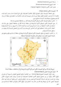
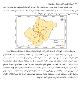
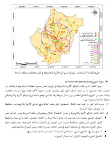
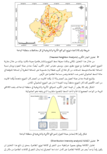
التحليل المكاني للمواقع الأثرية والتاريخية وعلاقتها بالعوامل الطبيعية والبشرية، دراسة حالة: منطقة الباحة
أشواق سعيد الأحمري
صاره الحبيب ورغي
كلية الآداب والعلوم الإنسانية || جامعة الملك عبد العزيز || جدة || المملكة العربية السعودية
Tab title
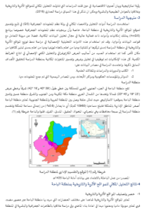
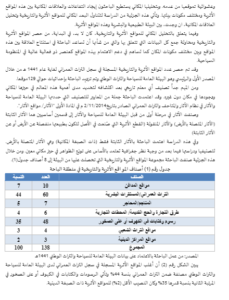
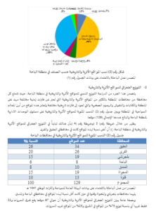
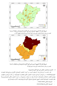
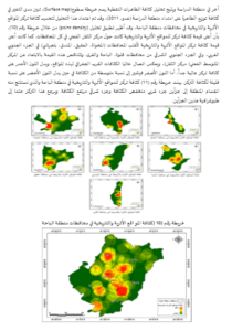
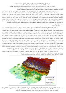
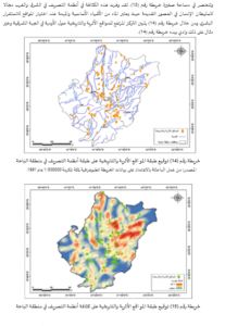
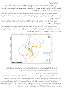
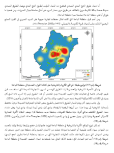
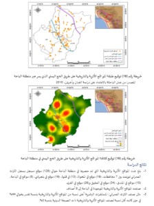
هدف هذا البحث إلى دراسة التوزيع الجغرافي للمواقع الأثرية والتاريخية في منطقة الباحة، وتحليل العلاقات المكانية بينها وبين باقي الظواهر الجغرافية والبشرية في المنطقة، مما يحقق لنا رؤية شاملة للوضع الراهن لهذه المواقع الأثرية والتاريخية، والسعي لتنمية الوعي بأهميتها السياحية لمنطقة الباحة. ولتحقيق أهداف البحث تم استخدام منهج التحليل المكاني في بيئة نظم المعلومات الجغرافية لقياس العلاقات المكانية بين الظاهرات في منطقة الدراسة من خلال ما تحتويه هذه التقنية من أدوات إحصاء وتحليل مكاني متعددة كما تم اعتماد الأسلوب الكارتوجرافى في التمثيل الخرائطي لعرض ورسم الخرائط باستخدام برنامج نظم المعلومات الجغرافية ArcGIS 10.6. وتوصلت الدراسة إلى حصر المواقع الأثرية والتاريخية في منطقة الباحة الذي بلغ حوالي 129 موقعاً توزعت بين 7 محافظات، كان توزيعها النسبي متباينا جدا بين الجزء الغربي والجزء الشرقي من المنطقة (حوالي 97 موقعا يقع شرق السروات و32 موقعاً غربها أي بنسبة توزيع 75% من المواقع في الشرق و25% من المواقع غرب السروات) في ارتباط وثيق بمظاهر السطح والموارد المائية والثروات المعدنية وطرق التجارة القديمة. وكان توزيع المواقع الأثرية والتاريخية في منطقة الباحة توزيعا متقاربا في مجمله (معامل صلة الجوار=0.63) وذلك لانحصار وصغر مساحات السهول الصالحة للاستيطان وطغيان المرتفعات شديدة الانحدار والصحراء الواسعة على مساحة منطقة الباحة. أما كثافة تركز المواقع الأثرية والتاريخية فقد كانت مرتفعة في الجزء الشرقي في حين انخفضت في الجزء الغربي من منطقة الدراسة. وأوصت الدراسة بأهمية استخدام تطبيقات نظم المعلومات الجغرافية للاستفادة منها في دراسة البعد المكاني للمواقع الأثرية والتاريخية ومدى التداخل المكاني بينها وبين مختلف الظواهر الطبيعية والبشرية في منطقة الدراسة. استغلال مخرجات التحليل المكاني في إعداد أطلس أثري يحتوي على خرائط ورسوم بيانية توضيحية وصور للمعالم والأماكن الأثرية في المنطقة لغرض استغلال وتسويق هذه الموارد الكامنة سياحيا. تشجيع الدراسات والأبحاث التي تسهم في إبراز أهمية المواقع الأثرية والتاريخية والتشجع على استغلالها في محاولة لدمج معمق لمنطقة الدراسة في المجالات السياحية. الكلمات المفتاحية: المواقع الأثرية والتاريخية، نظم المعلومات الجغرافية، التحليل المكاني، منطقة الباحة.